
Mangroves are prominent along the northwest coast of Australia. The first image collected by Landsat 9, on October 31, 2021, shows mangroves clustered in protected inlets and bays on the edge of the Indian Ocean. Fluffy cumulus clouds and high-altitude cirrus clouds hover nearby. The aqua colors of the shallow near-shore waters give way to the deep, dark blues of the ocean. Credit: NASA
Landsat 9, a joint mission between NASA and the U.S. Geological Survey (USGS) that launched on September 27, 2021, has collected its first light images of Earth.
The images, all acquired on October 31, are available online. They provide a preview of how the mission will help people manage vital natural resources and understand the impacts of climate change, adding to Landsat’s unparalleled data record that spans nearly 50 years of space-based Earth observation.
“Landsat 9’s first images capture critical observations about our changing planet and will advance this joint mission of NASA and the U.S. Geological Survey that provides critical data about Earth’s landscapes and coastlines seen from space,” said NASA Administrator Bill Nelson. “This program has the proven power to not only improve lives but also save lives. NASA will continue to work with USGS to strengthen and improve accessibility to Landsat data so decision makers in America – and around the world – better understand the devastation of the climate crisis, manage agricultural practices, preserve precious resources and respond more effectively to natural disasters.”
Animation of the Landsat 9 spacecraft in orbit around Earth, passing over the Western US and Baja California. The satellite will travel at 7.5 km/second, circling the globe every 99 minutes at an altitude of 705 km (438 miles). Landsat 9 will image a swath 185 km (115 miles) in width and complete about 14 orbits each day, thereby imaging every part of Earth every 16 days. Credit: NASA’s Goddard Space Flight Center/Conceptual Image Lab
These first light images shows Detroit, Michigan, with neighboring Lake St. Clair, the intersection of cities and beaches along a changing Florida coastline and images from Navajo Country in Arizona that will add to the wealth of data helping us monitor crop health and manage irrigation water. The new images also provided data about the changing landscapes of the Himalayas in High Mountain Asia and the coastal islands and shorelines of Northern Australia.
Landsat 9 is similar in design to its predecessor, Landsat 8, which was launched in 2013 and remains in orbit, but features several improvements. The new satellite transmits data with higher radiometric resolution back down to Earth, allowing it to detect more subtle differences, especially over darker areas like water or dense forests. For example, Landsat 9 can differentiate more than 16,000 shades of a given wavelength color; Landsat 7, the satellite being replaced, detects only 256 shades. This increased sensitivity will allow Landsat users to see much more subtle changes than ever before.
“First light is a big milestone for Landsat users – it’s the first chance to really see the kind of quality that Landsat 9 provides. And they look fantastic,” said Jeff Masek NASA’s Landsat 9 project scientist at Goddard Space Flight Center. “When we have Landsat 9 operating in coordination with Landsat 8, it’s going to be this wealth of data, allowing us to monitor changes to our home planet every eight days.”
Landsat 9 carries two instruments that capture imagery: the Operational Land Imager 2 (OLI-2), which detects visible, near-infrared and shortwave-infrared light in nine wavelengths, and the Thermal Infrared Sensor 2 (TIRS-2), which detects thermal radiation in two wavelengths to measure Earth’s surface temperatures and its changes.
These instruments will provide Landsat 9 users with essential information about crop health, irrigation use, water quality, wildfire severity, deforestation, glacial retreat, urban expansion, and more.
“The data and images from Landsat 9 are expanding our capability to see how Earth has changed over decades”, said Karen St. Germain, Earth Science Division director at NASA Headquarters in Washington. “In a changing climate, continuous and free access to Landsat data, and the other data in NASA’s Earth observing fleet, helps data users, including city planners, farmers and scientists, plan for the future.”
NASA’s Landsat 9 team is conducting a 100-day check-out period that involves testing the satellite’s systems and subsystems and calibrating its instruments in preparation for handing the mission over to USGS in January. USGS will operate Landsat 9 along with Landsat 8, and together the two satellites will collect approximately 1,500 images of Earth’s surface every day, covering the globe every eight days.
“The incredible first pictures from the Landsat 9 satellite are a glimpse into the data that will help us make science-based decisions on key issues including water use, wildfire impacts, coral reef degradation, glacier and ice-shelf retreat and tropical deforestation,” said USGS Acting Director Dr. David Applegate. “This historic moment is the culmination of our long partnership with NASA on Landsat 9’s development, launch and initial operations, which will better support environmental sustainability, climate change resiliency and economic growth – all while expanding an unparalleled record of Earth’s changing landscapes.”
NASA, USGS Landsat 9 Image Gallery
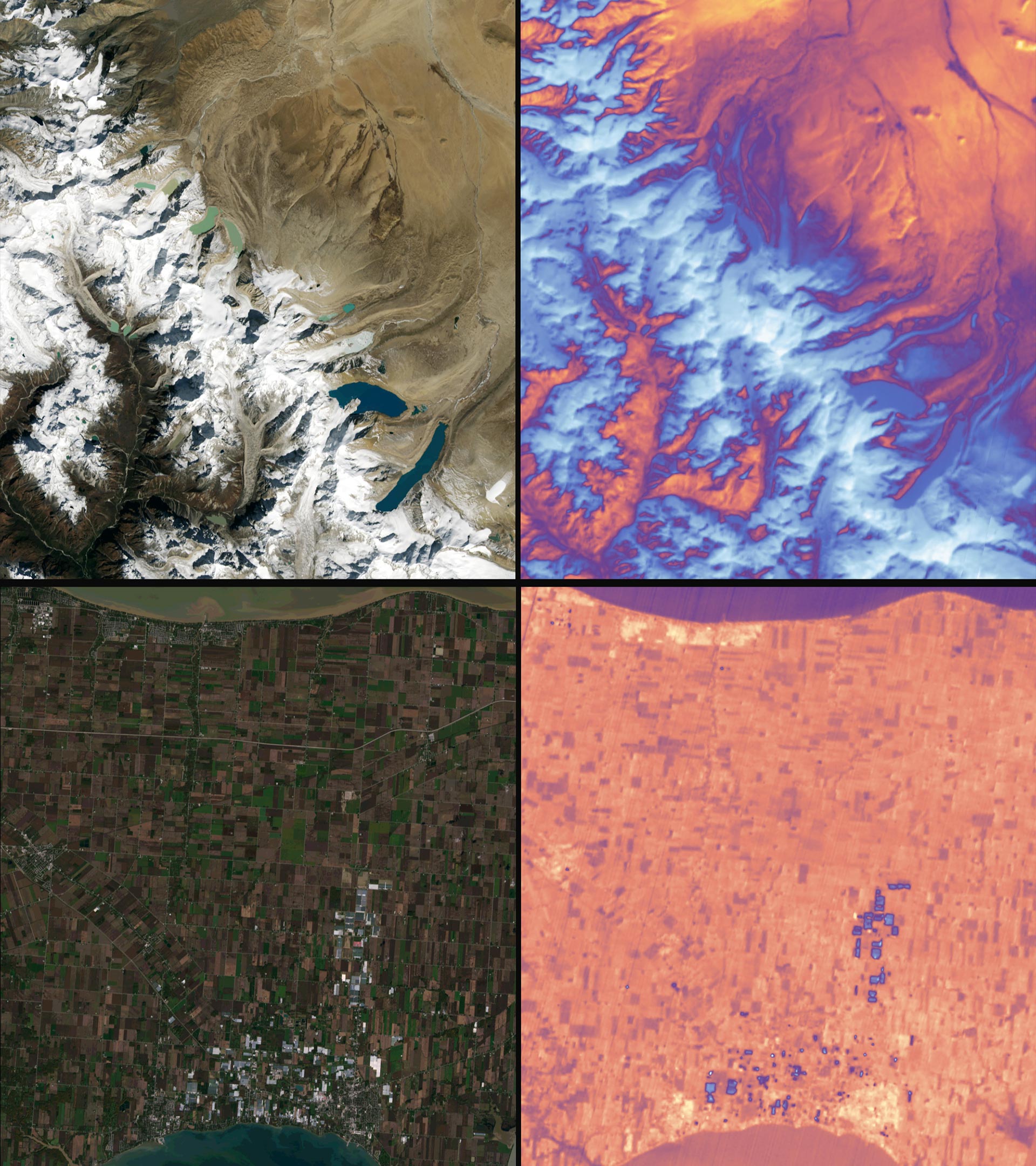
Landsat 9: Capturing a Broad Range of Data. Credit: NASA/USGS
Landsat 9 carries two instruments designed to work together to capture a broad range of wavelengths: the Operational Land Imager 2, or OLI-2, which detects nine different wavelengths of visible, near-infrared and shortwave-infrared light; and the Thermal Infrared Sensor 2, or TIRS-2, which detects two wavelengths of thermal radiation to measure slight changes in temperature. Data from both instruments are shown in the two pairs in this image.
The top left shows snow and glaciers in the Himalayan mountains, leading to the flat Tibetan Plateau to the north. The top right shows the same area in thermal data from the TIRS-2 instrument. Blue-white color indicates relatively cooler surface temperatures, while orange-red indicates warmer surface temperatures.
The bottom left shows the brown and green rectangles of farm fields in southern Ontario, sandwiched between Lake Erie and Lake St. Clair. The white and grey rectangles in the bottom of the image are produce greenhouses, which show up as blue-ish (relatively cooler) spots in the TIRS-2 image on the right.

Landsat 9: Western Australia. Credit: NASA/USGS
The first image collected by Landsat 9, on October 31, 2021, shows remote coastal islands and inlets of the Kimberly region of Western Australia. In the top middle section of the image, the Mitchell River carves through sandstone, while to the left Bigge Island and the Coronation Islands stand out in the Indian Ocean. Australia is a major international partner of the Landsat 9 program, and operates one of the Landsat Ground Network stations in Alice Springs.

Landsat 9: Navajo Nation. Credit: NASA/USGS
In the Western U.S., in places like the Navajo Nation as seen in this Landsat 9 image, Landsat and other satellite data help people monitor drought conditions and manage irrigation water. With only 85 rain gauges to cover more than 27,000 square miles, satellite data and climate models are filling the gaps to help the Navajo Nation monitor drought severity.
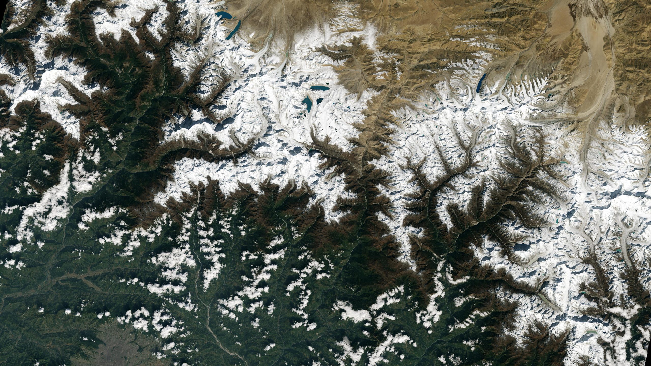
Landsat 9: Himalayas. Credit: NASA/USGS
The city of Kathmandu, Nepal, seen at the bottom left of this Landsat 9 image, lies in a valley south of the Himalayan Mountains between Nepal and China. Glaciers, and the lakes formed by glacial meltwater, are visible in the top middle of this image. In High Mountain Asia, many communities rely on meltwater from glaciers – and Landsat can help track how those glaciers are changing in a warming climate. Previous studies with Landsat have documented shrinkage of Himalayan glaciers, as well as changing lake levels the adjacent Tibetan plateau. From October 31, 2021, the first day of data collection for Landsat 9.
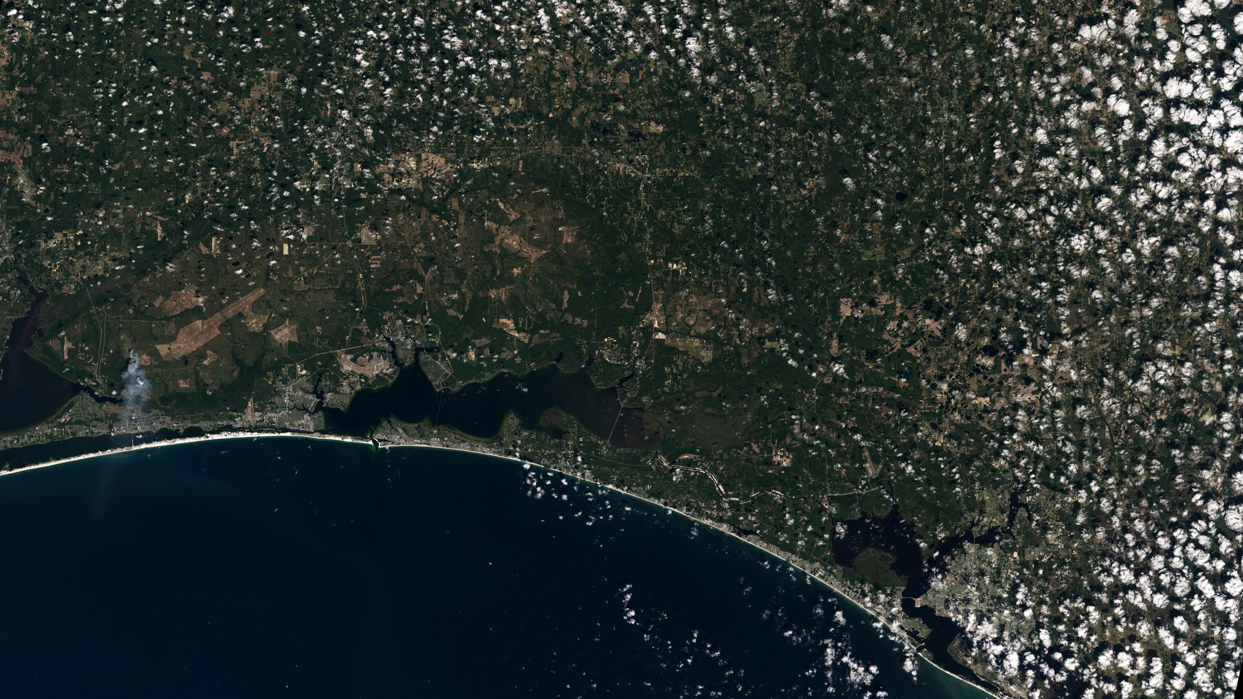
Landsat 9: Florida Panhandle. Credit: NASA/USGS
The white sands of Pensacola Beach stand out in this Landsat 9 image of the Florida Panhandle of the United States, with Panama City visible under some popcorn-like clouds. Landsat and other remote sensing satellites help to track changes to U.S. coastlines, including urban development and potential impacts of rising sea levels. From October 31, 2021, the first day of data collection for Landsat 9.

Landsat 9: Detroit and Lake Erie. Credit: NASA/USGS
Sediments swirl in Lake Erie and Lake St. Clair in this Landsat 9 image of both Detroit, Michigan, and Windsor, Ontario, from October 31, 2021. The Great Lakes serve as sources of freshwater, recreational activity, transport, and habitat for the upper-midwestern United States, and water quality remains a high priority. In warmer months, Landsat 9 observes swirls of green algae which can become harmful algal blooms. Landsat 9 will be able to help scientists and resource managers identify those blooms early, identifying areas to test further.
Landsat 9 data will be available to the public, for free, from USGS’s website once the satellite begins normal operations.
NASA manages the Landsat 9 mission development. Teams from NASA’s Goddard Space Flight Center in Greenbelt, Maryland, also built and tested the TIRS-2 instrument. NASA’s Launch Services Program, based at the agency’s Kennedy Space Center in Florida, managed the mission’s launch. The USGS Earth Resources Observation and Science (EROS) Center will operate the mission and manage the ground system, including maintaining the Landsat archive. Ball Aerospace in Boulder, Colorado, built and tested the OLI-2 instrument. United Launch Alliance is the rocket provider for Landsat 9’s launch. Northrop Grumman in Gilbert, Arizona, built the Landsat 9 spacecraft, integrated it with instruments, and tested it.
Article From & Read More ( NASA and USGS Release Stunning First Images From New Landsat 9 Spacecraft - SciTechDaily )https://ift.tt/3BV61E4
Science


No comments:
Post a Comment